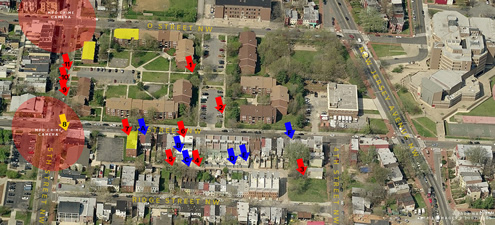
This is a whole different take on maps as community organizing tools. Richard Rogers, a local blogger for the “Mount Vernon Square”:http://en.wikipedia.org/wiki/Mount_Vernon_Square neighborhood of Washington, DC, is sick of all of the “troublemakers” in his area. By using publicly-available aerial photographs and a simple graphics editor, Rogers is creating a record of the problem as far as he sees it. Even more than that, this map can act as a place for coming together around the issue of neighborhood troublemakers.

The blogosphere makes it easy to combine postulations (_the alley between Ridge and N Streets NW is a favorite travel route of the trouble makers, as well as a new marketplace for drugs._) with harder data like the range of MPD CCTV cameras. It also makes it easy for relevant parties to discuss the issue. For example, the comments section after the post contains a discussion between readers and author about exactly where and why “troublemakers” are hanging out.
In case you don’t want to jump over to “Rogers’ blog”:http://lifein.mvsna.org/index.cfm/2008/7/14/Quick-Neighborhood-ViewNews and check it out yourself, here’s a legend for the map:
Yellow blocks — Suspected residences of neighborhood trouble makers
Red areas — Suspected usual range of crime cameras
Red arrows — Favorite hangout and loiter spots of neighborhood trouble makers
Yellow arrows — Hangout spots of neighborhood trouble makers during the day only
Blue arrows — Recent incident locations
Previously featured social-engagement through maps:
* “Governments shame property owners for heat waste”:http://duenos.net/article/249/Governmentsshamepropertyownersforheatwaste
* “Google Earth highlights crisis in Darfur”:http://duenos.net/article/140/GoogleEarthhighlightsCrisisinDarfur
Duenos.net
A blog about interestingness
